 Join Email List
For Email Marketing you can trust


Home > Bike Loops > Antoine Loop

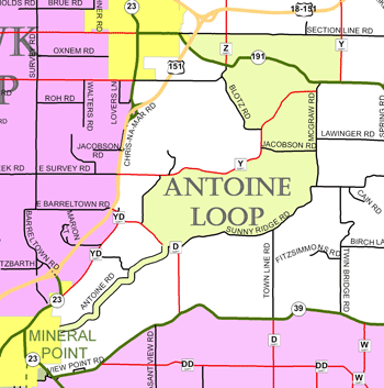
Antoine Loop (31 miles)
Parking and Restrooms: Mineral Point, Dodgeville
This ride takes you through the rural countryside between Mineral Point and Dodgeville. Convenient parking is available at Soldier’s Memorial Park in the very historic community of Mineral Point, named one of America’s Distinctive Destinations 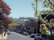 by the National Trust for Historic Preservation, home to Pendarvis Historic Site and a well respected artist community. The loop also takes you to the edge of Dodgeville, the county seat of Iowa County. Narrow curvy roads take you alongside wooded hillsides and valleys where streams meander next to old farmsteads and weathered trees that look like they have fascinating stories to tell.
 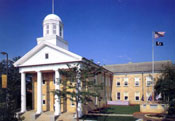 You’re likely to see cows dotting the hillsides, a sure sign that you’re in Wisconsin. If you’re looking for hills, you’ll find some challenging ones on this trip. At the top of each one awaits another vista that makes the climb worth the effort. Lose yourself in the beauty of the landscape. Be careful not to lose yourself too long though - there are a couple turns that are easy to miss. Here are three that you need to keep your eyes open for. McGraw Road is the very first left road off Sunny Ridge, about 3.5 miles from where you enter on County Road D. To find Blotz Road at the north end of the loop, you must turn left off Highway 191 onto Brennan Rd and then take a soft left where the road splits. That takes you to County Road Y. As you approach the end of this loop, you must turn left onto Governor Dodge Road, then right onto County Road D to get you to Antoine and right back where you started.
- Map View
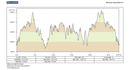
- Topography
- Photos
- Google Map
- Video
View Larger Image (printable)
Antoine Loop - 31 miles
View Larger Image (printable)
Coming soon! Select photos from scenic views, vistas, and overlooks throughout each loop.
Coming soon! Google maps of every loop, including markers for views, places of interest, restaurants, and so much more!!
![]()
![]()
Coming soon! Select video from scenic views, vistas, and overlooks throughout each loop.
The following link is to a high-resolution PDF (3 MB file) of the entire Cycle Southwest Wisconsin FREE Bicycle Trail Map. The PDF contains bookmarks that allow you to navigate your way to views of each individual map. Click here to view the map, or right click and chose “save as” to download the PDF.