
Home > Bike Loops > Big Patch Loop
Big Patch Loop (39 miles)
Parking and Restrooms: Cuba City, Benton, Hazel Green
Follow County Road D south from Platteville to College Farm Road, where you begin the Big Patch Loop, a 40 mile route through Grant and Lafayette Counties. College Farm Road stretches out for six miles, going straight as an arrow through cornfields on either side, with easy to moderate hills. The pattern continues as you head south on Sales Barn Road and across Hwy 81: wide open land and pretty easy peddling. Not until you’ve made your way through Jenkinsville and Benton, heading west toward Hazel Green, 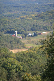 will the roads offer more challenging climbs. Hazel Green is just about the half way point, so enjoy a rest before heading north on Hwy 81, and then west into Grant County farm land. It’s pretty easy going on Louisburg Road, dropping downhill until you turn to the north on Center Road. From there, you have five miles of straight-ahead slow steady climbing, bordered by cropland and passing through small farming towns. Center Road becomes County Road D, and the final stretch has a lot of ups and downs, before it levels off and heads back into Platteville. Cuba City sits in the middle of this loop. You can access it by detouring off on County Rd H. Cuba City, known as the City of Presidents, honors all the U.S. Presidents with signage that lines the main thoroughfare.
- Map View
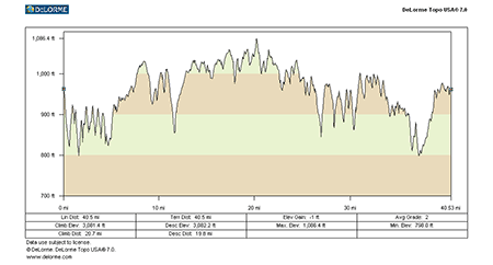
- Topography
- Photos
- Google Map
- Video
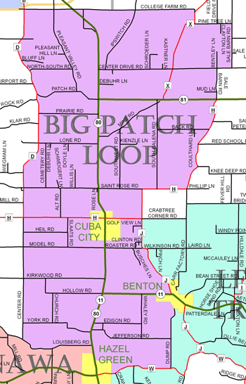
View Larger Image (printable)
Big Patch Loop - 39 miles
View Larger Image (printable)
Coming soon! Select photos from scenic views, vistas, and overlooks throughout each loop.
Coming soon! Google maps of every loop, including markers for views, places of interest, restaurants, and so much more!!
![]()
![]()
Coming soon! Select video from scenic views, vistas, and overlooks throughout each loop.
The following link is to a high-resolution PDF (3 MB file) of the entire Cycle Southwest Wisconsin FREE Bicycle Trail Map. The PDF contains bookmarks that allow you to navigate your way to views of each individual map. Click here to view the map, or right click and chose “save as” to download the PDF.
|