

Home > Bike Loops > Blackhawk Lake Loop
Blackhawk Lake Loop (45 miles)
Parking and Restrooms: Mineral Point, Linden, Cobb, Dodgeville
This loop will take you back to days of county fairs and roller coaster rides. The views are absolutely awe-inspiring. From the picturesque community of Mineral Point, follow Highway 39 to County Road E. You’ll ride past the Iowa County Airport and make a right turn on Keogh Springs Road, a very quiet, very scenic, very hilly road. You will end up at the very edge of the Village of Linden. Now you are going on an “alphabet soup” trip: County Road X to J to B to G …the route to the Village of Cobb. On the other side of Cobb, the view becomes spectacular as you turn onto County Road Q. 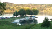 A couple miles off the loop is Blackhawk Lake Recreational Area, 600 acres of magnificent Wisconsin beauty. You could stay and enjoy the day on this “no wake” lake with great fishing, hiking/biking trails, horseshoe pits, volleyball and basketball courts, miniature golf and lots of picnicking areas. Back on the bike loop, you’ll find plenty of reasons why people love to live here. The road takes you beside magnificent rock outcroppings, gently winding streams, country churches and schoolyards of days gone by. As you exit County Road Q
 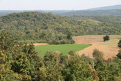 on Military Ridge Road, you’ll see Dodgeville up ahead, the home of Lands’ End and a National Historic District downtown. The Iowa County Courthouse is the oldest continually active courthouse in the state. You may also stop and see the restored mining cabin from Henry Dodge’s original mining party before he was inaugurated as the first territorial governor in nearby Mineral Point.
- Map View
- Topography
- Photos
- Google Map
- Video
View Larger Image (printable)
Blackhawk Lake Loop - 45 miles
View Larger Image (printable)
Coming soon! Select photos from scenic views, vistas, and overlooks throughout each loop.
Coming soon! Google maps of every loop, including markers for views, places of interest, restaurants, and so much more!!
![]()
![]()
Coming soon! Select video from scenic views, vistas, and overlooks throughout each loop.
The following link is to a high-resolution PDF (3 MB file) of the entire Cycle Southwest Wisconsin FREE Bicycle Trail Map. The PDF contains bookmarks that allow you to navigate your way to views of each individual map. Click here to view the map, or right click and chose “save as” to download the PDF.
|