

Home > Bike Loops > Castle Rock Loop
Castle Rock Loop (30 miles)
Parking and Restrooms: Fennimore
This loop heads out of Fennimore on Hwy 61. Expect increased traffic, but don’t worry because there is a wide paved shoulder. If you are a golfer, stop at Hickory Grove Golf Course for a change of pace. 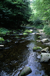 Along County Road T the rolling hills and rural views make for a very pleasant ride. At the village of Hickory Grove turn right on County Road M. As you approach the intersection with County Road GQ you will follow the beautiful Blue River. As you come out of the village of Castle Rock you will follow Castle Rock Creek, a class 1 trout stream with public easements west of Castle Rock. The richness of nature is abundant here! You will be sharing the area with all sorts of wildlife - eagles, turkeys, deer and birds galore. Enjoy the views and rolling hills as you take County Road Q back to Hwy 61 on your way back into Fennimore where you’ll find plenty of small town hospitality.
- Map View
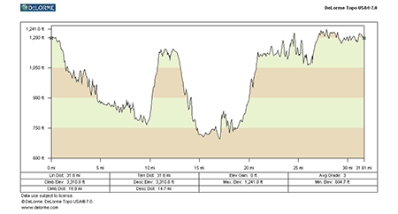
- Topography
- Photos
- Google Map
- Video
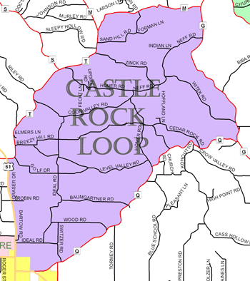
View Larger Image (printable)
Castle Rock Loop - 30 miles
View Larger Image (printable)
Coming soon! Select photos from scenic views, vistas, and overlooks throughout each loop.
Coming soon! Google maps of every loop, including markers for views, places of interest, restaurants, and so much more!!
![]()
![]()
Coming soon! Select video from scenic views, vistas, and overlooks throughout each loop.
The following link is to a high-resolution PDF (3 MB file) of the entire Cycle Southwest Wisconsin FREE Bicycle Trail Map. The PDF contains bookmarks that allow you to navigate your way to views of each individual map. Click here to view the map, or right click and chose “save as” to download the PDF.
|