
Home > Bike Loops > Dunburton Loop
Dunburton Loop (30 miles)
Parking and Restrooms: Shullsburg, Gratiot
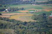
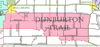
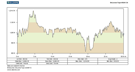
The 28-mile Dunbarton Trail starts in historic Shullsburg and then heads east along County Road A to quiet Dunbarton Road. For ten miles, the narrow road cuts through fields of corn and soybeans, past Wisconsin family farms, and along beautiful wooded hills. Ivy covered red barns and moderately challenging hills dot the course.  Turning right on Hwy. 78, the trail steadily climbs over 300 feet before leveling out on a plateau of open cropland for over three miles. County Road W takes you back toward Shullsburg, with twelve miles of straight open roadway. The first seven miles are relatively flat, but the stretch concludes with challenging hills and fantastic views to the west. A short stretch on County Road O, takes you over some smaller hills and straight back to Shullsburg’s Badger Park. Nearby is one of nature’s optical illusions called Gravity Hill. If you’ve got a car handy, take a drive out of town approximately two miles on County Road U where it plunges down a steep hill, across a low area, and curves back up a steeper hill. Stop your car about three-quarters of the way down the first hill, just short of the 25 mph sign that announced the curve back up the other side. From here, U appear to drop considerably to the valley floor before rising again. Place the car in neutral and you will be rolling backward up the hill, slowly at first then faster and faster.
- Map View
- Topography
- Photos
- Google Map
- Video

View Larger Image (printable)
Dunburton Loop - 30 miles

View Larger Image (printable)
Coming soon! Select photos from scenic views, vistas, and overlooks throughout each loop.

Coming soon! Google maps of every loop, including markers for views, places of interest, restaurants, and so much more!!


Coming soon! Select video from scenic views, vistas, and overlooks throughout each loop.

The following link is to a high-resolution PDF (3 MB file) of the entire Cycle Southwest Wisconsin FREE Bicycle Trail Map. The PDF contains bookmarks that allow you to navigate your way to views of each individual map. Click here to view the map, or right click and chose “save as” to download the PDF.
