

Home > Bike Loops > Mill Creek Loop
Mill Creek Loop (34 miles)
Parking and Restrooms: Arena, Barneveld, Ridgeway
This scenic ride takes you along two small streams. On the east side of the loop you’ll be riding alongside Blue Mounds Branch. The Mill Creek meanders along the west side of the loop. The village of Arena is at the north end. Home to the original co-jack cheese, you might like to pause for a cheese-making demo or just stop and grab some squeaky cheese curds made daily. The village of Barneveld, at the south end 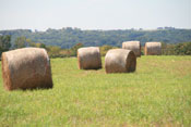 of the loop, is a community that has re-built itself after being leveled in a 1984 tornado. The farmlands mixed with woodlands, hills and valleys create a beautiful mosaic for your enjoyment along this loop. Birch Lake Park and the historic Hyde Church are located on County Road T. Mill Road between County Road T and County Road H takes you by the scenic, historic Hyde mill and dam. The Hyde general store is just south of Mill Road on County Road H. A couple of more interesting points to check out are the Mill Creek Cheese Factory and St. John the Baptist Church.
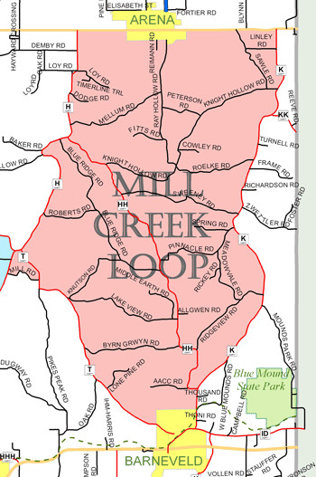
View Larger Image (printable)
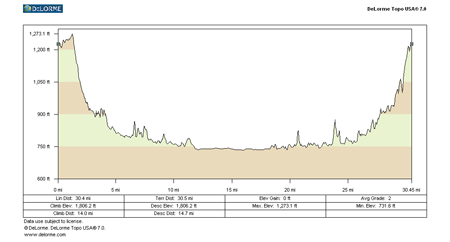
Mill Creek Loop - 34 miles
View Larger Image (printable)
Coming soon! Select photos from scenic views, vistas, and overlooks throughout each loop.
Coming soon! Google maps of every loop, including markers for views, places of interest, restaurants, and so much more!!
![]()
![]()
Coming soon! Select video from scenic views, vistas, and overlooks throughout each loop.
The following link is to a high-resolution PDF (3 MB file) of the entire Cycle Southwest Wisconsin FREE Bicycle Trail Map. The PDF contains bookmarks that allow you to navigate your way to views of each individual map. Click here to view the map, or right click and chose “save as” to download the PDF.
|