

Home > Bike Loops > Prairie Loop
Prairie Loop (50 miles)
Parking and Restrooms: Mineral Point, Shullsburg, Darlington
Enjoy the panoramic views of Southwest Wisconsin on this trail. Traveling up and down the hills between Mineral Point and Shullsburg you’ll find yourself stopping just to take it all in. Roads are very quiet with little traffic. Farms and wildlife are all around you. Stop and see the mini-horse farm on County Road O. 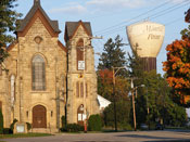 From Hwy G. to the north, the trail is curvier and has more hills. Take O to Business 151 into Mineral Point. Turn right on High Street at the Watertower Park and you’ll see the downtown straight ahead. Mineral Point, the first city in Wisconsin to be listed on the National Register of Historic Places, is often compared to European villages. At the bottom of High Street, turn right onto Commerce Street. A couple
 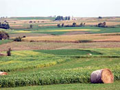 blocks ahead are the oldest existing railroad depot in Wisconsin. This is the trailhead to the Cheese Country Trail. Follow the trail 1 mile to Ferndale where you’ll be back on the loop. You will come to within 1 mile of Darlington, so it’s an easy detour into this Lafayette County Seat. Darlington is known as the Pearl of the Pecatonica for the days when clams were harvested to produce pearl button blanks. Then it’s back onto Shullsburg where you might want to descend into an authentic 1827 mine shaft and see how the original Wisconsin "badgers" chiseled out a living.
- Map View
- Topography
- Photos
- Google Map
- Video
View Larger Image (printable)
Prairie Loop - 50 miles
View Larger Image (printable)
Coming soon! Select photos from scenic views, vistas, and overlooks throughout each loop.
Coming soon! Google maps of every loop, including markers for views, places of interest, restaurants, and so much more!!
![]()
![]()
Coming soon! Select video from scenic views, vistas, and overlooks throughout each loop.
The following link is to a high-resolution PDF (3 MB file) of the entire Cycle Southwest Wisconsin FREE Bicycle Trail Map. The PDF contains bookmarks that allow you to navigate your way to views of each individual map. Click here to view the map, or right click and chose “save as” to download the PDF.
|