

Home > Bike Loops > Rodgers Branch Loop
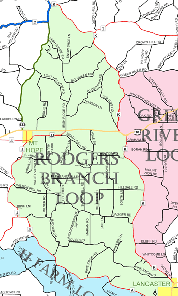
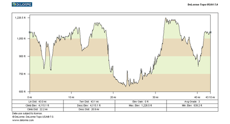
Rodgers Branch Loop (41 miles)
Parking and Restrooms: Lancaster
This is the route used for the Grant County Cycling Classic and a favorite of local cyclists. It is a hilly and very challenging loop, but the scenery makes it all worth the effort. Start this loop in Lancaster and follow County Road K on rolling hills with views of the surrounding farmland. As you cross Hwy 18 and pass through the village of Mt. Ida you will drop into the Green River Valley. From there you coast downhill all the way to the village of Werley, which was the last stop of the narrow gauge train that came out of Boscobel. 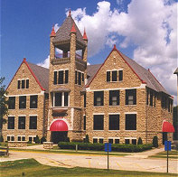 On Green River Road you will follow the Big Green River as it meanders along. There are public easements along much of the river, so feel free to cast a line or wet your toes. On the loop back, you pass through the village of Mount Hope and connect with County Road J to County Road A. The return follows the Rodgers Branch of the Grant River for most of the way - more beautiful rolling hills and one panoramic view after another. This will bring you back into Lancaster where you can get a history lesson as you stroll the courthouse lawn and view the monuments and statues on the square.
- Map View
- Topography
- Photos
- Google Map
- Video
View Larger Image (printable)
Rodgers Branch Loop - 41 miles
View Larger Image (printable)
Coming soon! Select photos from scenic views, vistas, and overlooks throughout each loop.
Coming soon! Google maps of every loop, including markers for views, places of interest, restaurants, and so much more!!
![]()
![]()
Coming soon! Select video from scenic views, vistas, and overlooks throughout each loop.
The following link is to a high-resolution PDF (3 MB file) of the entire Cycle Southwest Wisconsin FREE Bicycle Trail Map. The PDF contains bookmarks that allow you to navigate your way to views of each individual map. Click here to view the map, or right click and chose “save as” to download the PDF.
|