

Home > Bike Loops > State Park Look
State Park Loop (27 miles)
Parking and Restrooms: Dodgeville, Spring Green
This large loop is named for two state parks at either end -- Governor Dodge State Park on the south, and Tower Hill State Park on the north. 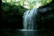 Both have parking and facilities, but require park fees for motor vehicles. Governor Dodge State Park has hiking/biking trails, swimming, camping. With 5,270 scenic acres of steep hills, bluffs, and deep valleys plus two lakes and a waterfall, it is one of Wisconsin’s largest state parks. Tower Hill State Park is noted for the restored shot tower from
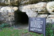 the early lead mining era. Challenging bluff trails, panoramic views, camping, canoeing and fishing on the Wisconsin River are available May through October. Other places of interest along this route are Taliesin, American Players Theater, House on the Rock Resort and Golf Course, and the House on the Rock. A scenic overlook on Hwy 23 between the
  House on the Rock and Taliesin presents you with an awe-inspiring view of the valley. Along the way on County Road Z, you will be riding through farmland that is interspersed with wooded valleys and plenty of places to stop and enjoy more great views.
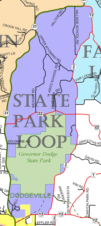
View Larger Image (printable)
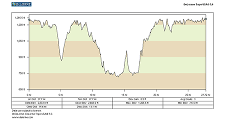
State Park Loop - 27 miles
View Larger Image (printable)
Coming soon! Select photos from scenic views, vistas, and overlooks throughout each loop.
Coming soon! Google maps of every loop, including markers for views, places of interest, restaurants, and so much more!!
![]()
![]()
Coming soon! Select video from scenic views, vistas, and overlooks throughout each loop.
The following link is to a high-resolution PDF (3 MB file) of the entire Cycle Southwest Wisconsin FREE Bicycle Trail Map. The PDF contains bookmarks that allow you to navigate your way to views of each individual map. Click here to view the map, or right click and chose “save as” to download the PDF.
|