

Home > Bike Loops > Taliesin Loop
Taliesin Loop (32 miles)
Parking and Restrooms: Spring Green
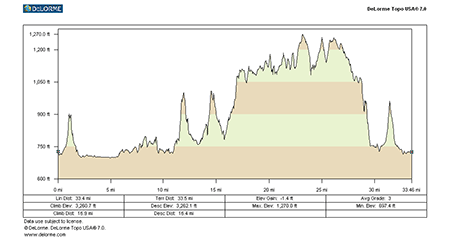
This is where Frank Lloyd Wright found his passion for creating and living with nature. You will find his inspiration contagious along this route. Begin your ride with a view of Taliesin North, Wright’s home, studio and school. 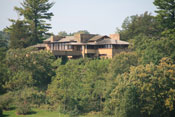 After a steep climb, stop at the scenic overlook for impressive perspective of the area that informed Wright’s design concepts. The House on the Rock, one of the state’s largest attractions, is just down the road. Photo opportunities abound along this route with some very scenic views from ridge tops and throughout the verdant valleys. The Wisconsin River valley is replete with breathtaking
  vistas that have inspired people for many ages. Elevation changes make this route a challenge but a delightful ride. State Highway 23 is relatively busy, but it has good paved shoulders. The south and west portions of this loop negotiate several good hills and should be considered difficult.
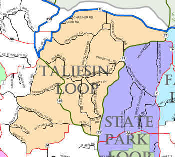
View Larger Image (printable)
Taliesin Loop - 32 miles
View Larger Image (printable)
Coming soon! Select photos from scenic views, vistas, and overlooks throughout each loop.
Coming soon! Google maps of every loop, including markers for views, places of interest, restaurants, and so much more!!
![]()
![]()
Coming soon! Select video from scenic views, vistas, and overlooks throughout each loop.
The following link is to a high-resolution PDF (3 MB file) of the entire Cycle Southwest Wisconsin FREE Bicycle Trail Map. The PDF contains bookmarks that allow you to navigate your way to views of each individual map. Click here to view the map, or right click and chose “save as” to download the PDF.
|