

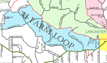
Home > Bike Loops > U Farm Loop
U Farm Loop (29 miles)
Parking and Restrooms: Bloomington, Lancaster
Starting in Bloomington, take Hwy 35/133 south; go left on County Road A. Turn Right on Slabtown Rd. Be ready for a huge climb from the valley bottom to the ridge top, enjoy the views of farms and fields from the ridge. Continue riding the ridge as you turn left on Cemetery Rd. Enjoy the long downhill as Cemetery Rd. meets University Farm Rd. Turn right on University Farm Rd. and ride the river bottom.  As you meander along with the Blake Fork, a tributary of the Grant River, savor the bucolic views of grazing cows and cornfields stretching out on the rolling hills. Turn left on Hwy 35/81 and head toward Lancaster. Turn left on Old Potosi Rd/McKinnley St. at the outskirts of Lancaster. If you need a break, continue straight on Hwy 35 into the city of Lancaster. Old Potosi Rd/McKinnley St. takes you through residential Lancaster.
 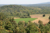 Rest up! You’ll need your strength for two challenging hills when you turn left onto County Road A. You will drop down to the river valley to cross the Grant River then climb to the ridge and drop down again to cross the Little Grant River then climb to the ridge once more. Turn left on Bedrock Road where you will enjoy a steep descent and then another challenging climb to the ridge followed by another enjoyable descent where you continue along the valley floor. Take County Road A back into Bloomington. Reward yourself for completing this very challenging loop.
 Optional Detour
Take a detour to the junction of Slabtown Rd and Hwy 35 and visit the Historical Marker for the Pleasant Ridge African American Community. Pleasant Ridge was a unique community of African American farmers. In about 1850, the Shepard family began this farming community on land purchased from William Horner, who brought the Shepards from Virginia as freed slaves. Over the next decade the Pleasant Ridge community became a welcoming home to many ex-slaves. In 1873, with their white neighbors, Pleasant Ridge residents built one of the first integrated schools in the nation; it accepted both black and white students and employed black as well as white teachers. Some of its pupils grew up to graduate from college and become teachers themselves. The white and black neighbors also created other facilities together, building the United Brethren Church in 1884 and a community hall in 1898. Today, only the Pleasant Ridge Cemetery remains as a reminder of this early African American community.
- Map View
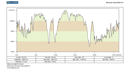
- Topography
- Photos
- Google Map
- Video
View Larger Image (printable)
U Farm Loop - 29 miles
View Larger Image (printable)
Coming soon! Select photos from scenic views, vistas, and overlooks throughout each loop.
Coming soon! Google maps of every loop, including markers for views, places of interest, restaurants, and so much more!!
![]()
![]()
Coming soon! Select video from scenic views, vistas, and overlooks throughout each loop.
The following link is to a high-resolution PDF (3 MB file) of the entire Cycle Southwest Wisconsin FREE Bicycle Trail Map. The PDF contains bookmarks that allow you to navigate your way to views of each individual map. Click here to view the map, or right click and chose “save as” to download the PDF.
|